Decennie des Nations Unies pour la Biodiversite
![]()
 Données satellitaires - Feux - Exploitation illicite
New satellite data reveals active burning in Sava, a region in Madagascar that has been ravaged by illegal logging for rosewood and other valuable rainforest timber.
| Concerned URL | http://news.mongabay.com/2010/1227-sava_fires.html |
|---|---|
| Source | wildmadagascar.org |
| Release date | 03/01/2011 |
| Geographical coverage | Région SAVA,Madagascar, |
| Keywords | Données satellitaires,feux,exploitations illicites, |
According to data
provided by the Fire Alert System, a joint monitoring program run by
NASA, Conservation International and the University of Maryland, more
than 1,100 fires have burned in Andapa, Antalaha, Sambava, and
Vohimarina—districts where the bulk of Madagascar's illegal logging is
taking place—since October 1. Roughly a quarter of these fires have
burned in, or on the margins, of forest areas. A handful of fires have
occurred in protected areas, including Masoala National Park, a World
Heritage Site that has been besieged by illegal logging since last year.
A biological survey in October turned up evidence of as many as 10,000
people living in the park.
The remote sensing data seems to support on-the-ground reports of a
large number of fires in the region. Dry conditions are likely a
contributing factor—the rainy season is late this year, so annual fires
set for land-clearing are burning longer than usual. Politic conditions
may also be a factor: since last year's military coup, governance in
Madagascar has been substantially weakened. As a result, there is less
control over illegal fire-setting and logging.
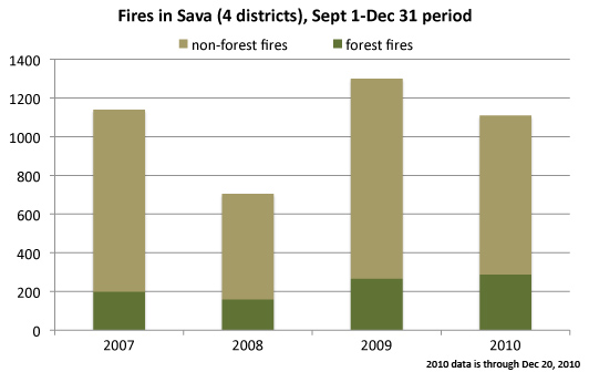
Nevertheless, while the aggregate number of fires for October through
December 2010 are higher than normal, they are down from the year
earlier period, when more than 1,300 were recorded. The number of fires
burning in forest areas is similar over the past two years, but
markedly higher than 2008 and 2007, the first year the Fire Alert System
was operational.
Neighboring regions are also seeing heavy burning. Analanjirofo, the
region which contains parts of Makira and Masoala protected areas, had
553 forest fires in October and November, up from 421 a year earlier.
Diana, which houses Analamerana and
Andavakoera-Andrafiamenta-Ambohipiraka protected areas, and Sofia, which
borders Makira, had more than 500 forest fires during the two months.
Final data for December 2010 will be available on january 2011, making annual comparisons more complete.
Please note that this information has expired.